The recent massive flooding in Western Japan from Kyushu to Gifu has made many of us living in Japan check the vulnerability of our own homes to severe flooding. One way to do this is to check the hazard maps published by local governments.
As listed below, Shiga Prefecture has published online hazard maps for floods, landslides, earthquakes, and nuclear power plant radiation leakage. The hazard areas are color-coded and quite detailed (you can zoom in and scroll around your neighborhood). The green “running man” icon indicates refuge areas (parks, schools, etc.). All the hazard maps are in Japanese only, no versions in English or other foreign languages. And so I’ll explain about these maps so you can have a basic understanding.
We have to look at the maps as just a rough guide. It’s impossible to accurately predict how your neighborhood or home will be affected in a major disaster (especially earthquakes).
The best thing to do is to be prepared. But it’s hard to be fully prepared for something you’ve never experienced or something that strikes unexpectedly. At the very least, always keep a stock of bottled water (at least one week’s worth), canned food and snacks, first-aid kit, and a hard hat. And whenever you go out, always carry water and snacks in case you get stuck on a train in an earthquake, etc.
Japan is certainly a disaster-prone country. Earthquakes, heavy rains, typhoons, floods, landslides, tornadoes, tsunami, volcanic eruptions, leaks from nuclear power plants, and man-made errors. All of these can be quite frightening, but keep in mind that the chances of you dying or getting injured by any of the above is still minuscule compared to dying due to a traffic accident, smoking, consuming too much fat and sugar, not exercising enough, or a disease like cancer. So before looking down on Japan for its disasters, look down on your own bad habits and lifestyle that may affect your health and lifespan. (Eat more vegetables, fruits, and natto, and exercise more.)
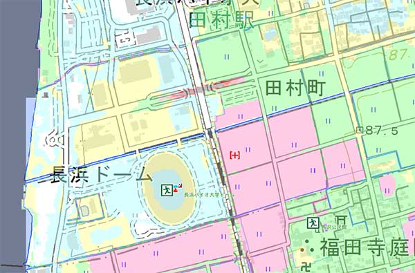
滋賀県防災情報マップ(滋賀県ハザードマップ)
Shiga Prefecture Flood Hazard Map
http://shiga-bousai.jp/dmap/map/index?l=M_r_k_risk_map&z=&lon=&lat=
This map highlights the areas in Shiga that can get flooded due to heavy rain, overflowing rivers, or breached riverbanks. The map’s sidebar lets you set various parameters such as the probability (once in 200, 100, or 10 years) of flooding. By default, the map shows a probability of once in 200 years. The default color coding is as follows:
Aqua: Areas that can get flooded up to 0.5 meter.
Yellow: Areas that can get flooded up to 1 meter.
Green: Areas that can get flooded up to 2 meters (1st floor height).
Pink: Areas that can get flooded up to 3 or 4 meters.
Red: Areas that can get flooded up to 5 meters (2nd floor height).
River Cameras in Shiga
http://c.shiga-bousai.jp/shigapref/pc/index.html
Shiga Prefecture has live cameras monitoring major rivers. They are connected online so we can see the river’s water level. On this map, click on a camera icon to view the camera’s river image online. The image is updated every 5 min. (It’s not a video.) The map also has icons indicating the water level. Blue is normal while red is the river’s flood warning level.
Shiga Prefecture Landslide Hazard Map
http://shiga-bousai.jp/dmap/map/index?l=M_d_risk_map&z=&lon=&lat=
This map highlights the areas in Shiga vulnerable to landslides. Mountainous areas where a landslide can occur are outlined by a brown polygon and filled with slanted, vertical, or horizontal lines. (These lines indicate the type of landslide.) The yellow areas show where the landslide can bury homes and property. Again, this map is only a rough guide. Heavy rains or prolonged rains can well expand the landslide or mudflow to cover a larger area than indicated in yellow (土砂洪水氾濫). (The landslide hazard maps for areas in Okayama and Hiroshima flooded in early July 2018 proved to be woefully inaccurate since the landslides affected a much larger area than shown on the maps.) If you live near a mountain, you need to be extra vigilant during and after heavy rains.
Shiga Prefecture Earthquake Hazard Map
http://shiga-bousai.jp/dmap/map/index?l=M_e_risk_map&z=&lon=&lat=
This is an interesting map, but I wouldn’t rely on it too much. In fact, it might be pretty useless. There are just too many unknown factors, especially unknown earthquake faults. The two major earthquake faults known in Shiga are the Yanagase Fault (柳ヶ瀬断層) in northeastern Shiga in Nagahama and the Western Lake Biwa Fault Area (琵琶湖西岸断層帯) which is a series of faults along Western Shiga from Otsu to Takashima. The last major earthquake that struck Shiga was the Anegawa Earthquake (Yanagase Fault) in 1909 striking Nagahama (Torahime, Anegawa River area, and Gifu). It was magnitude 6.8 and 35 people died and 643 people were injured in Shiga. Over 2,000 homes in Shiga collapsed.
The default color coding is as follows:
Blue: Areas that may have a Magnitude -5 earthquake.
Green: Areas that may have a Magnitude 5+ earthquake (bookshelves and cupbards falling over).
Yellow: Areas that may have a Magnitude -6 earthquake (roof tiles may fall off, furniture falling over).
Orange: Areas that may have a Magnitude 6+ earthquake (buildings can collapse).
Red: Areas that may have a Magnitude 7 earthquake (buildings can collapse).
Shiga Prefecture Nuclear Plant Radiation Hazard Map
http://shiga-bousai.jp/dmap/map/index?l=M_g_gensiryoku_map&z=&lon=&lat=
This map shows a 30 km radius (in orange) from each nuclear plant in Fukui Prefecture. Of course, the radiation can spread beyond this radius depending on prevailing winds. Local officials are still trying to figure out how people can evacuate northern Shiga en masse in case of a major radiation breach in Fukui. If there is a major radiation leak, say good-bye to our water supply and endemic fish. People in Kyoto and Osaka will also suffer. And yet, big business and local politicians think it is worth the risk.
Index of Shiga Prefecture’s hazard maps (in Japanese)
http://shiga-bousai.jp/dmap/top/index
Take care everyone.


